We finally opened the beta for Earth Connector for Revit to anyone, and publicized it as well. (Those few of you who read my blog were the only ones who really knew about the beta previously).
It's available here for download.
We're still trying to incorporate the feedback from our original beta testers - but the release seemed solid enough to open it up to the world.
Also in the past few weeks, the new KML spec for Google Earth 4.0 came out. While the existing KML format still exists, they've included the ability to reference in a COLLADA file as part of a KML file. This has several implications for the Earth Connector tools...
File Format
Based on what we've read so far, the Collada format is a bit more capable than KML. While I don't think it will be adopted widely by the CAD community, it WILL help us overcome some of the challenges that we've had with representing complex geometry in KML. (KML represented each surface only based on the points describing its boundary - which made certain surfaces as simple as cylinders and as complicated as concave/convex surfaces very hard to represent).
File Size
One of the things that the existing KML format was horrible about was file size. There was no way to say "here is how you describe this window - now I have 1000 of them"... You actually had to make all thousand separately. This made for a big KML/KMZ file, and helped in bringing Google Earth to its knees on occasion.
Monolithic
One thing, for better or worse, with the new KML mechanism for incorporating a COLLADA file is that the "model" is monolithic... One building represents one "item" in the KML file and the "My Places" pane.
Why this is Good
This is good because they now have the ability to move your COLLADA building around directly within Google Earth... (making the positioning part of the job MUCH easier)...
Why I suspect this is Bad
I suspect that this is bad for some people in the AEC world. One of the real benefits to people who care about more than just the "look" of the building is the ability to "take apart" the building and understand its contents. Look, for example, at the sample that we post on our site for Revit. In this house model, you can toggle on and off the roof and ceilings to see inside, the walls for other views, etc. You can even pick on each object in the house and see information about that Object from Revit (door make and model, wall square footage, etc).
While I don't have any real proof yet, I presume that there is a segment of the population that will like that capability... and while I can imagine some hacks to make it happen in the new Collada format, it will also destroy some of the benefits of Collada.
In Summary
I'm still excited to see where it all goes... It's going to be interesting to support the new file formats, as well as figuring out how it will all work with Revit, AutoCAD and Civil3D.
PostScript
For those of you who have been asking... the AutoCAD 2007 version will be posted shortly... We had originally planned support for AutoCAD Solids and Regions, but we're re-evaluating in the face of the new format.
Tuesday, June 27, 2006
Earth Connector for Revit - Open Beta
Friday, June 16, 2006
Google Earth 4.0: A New Ballgame
Here's a lesson in "be careful what you wish for"...
All along the development of Earth Connector for AutoCAD and Earth Connector for Revit (soon to be public, I promise!), I've been grumbling - the buildings look so flat, there's no textures... Google Earth has such fast rendering, but the 3D geometry is so... basic.
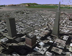
So along comes Google Earth 4.0 (Beta). And right off the bat, the pictures show even more impressive 3D, along with far more realistic texturing (see picture).
As I dig into what makes it possible though, I start to feel mildly ill... Instead of improving upon the geometry capabilities of KML, Google has gone down a completely different route. They've brought in Collada - an industry-standard XML format for representing 3D models (at least it claims to be industry-standard in some industries - I personally had not heard of it - apparently it's well integrated with Maya, Studio Max, etc).
The Good
Our recent efforts to pull more AutoCAD solid and region data into KML have shown the fundamental inadequacy of KML for more complicated surfaces. Because KML represents faces by their boundaries, Google Earth arbitrarily defines what a face looks like (and for a given boundary, there are many possible permutations when you talk about more complicated, non-planar faces).
Further, by pushing this data into the Collada file and then referencing it within KML, this should make it easier to "reposition" data once it has been generated (since the KML does some of the work we currently do to position the 3D model at a given lat/long).
In fact, the new mechanism for "Placing" a 3D model in space is awesome... once you have the 3D completed, you just drag it into the right location all within Google Earth (for you current architectural Earth Connector users, you know how much better that is).
The Bad
While everything in Earth Connector will continue to work, if we want to move forward with the "nicer" 3D - we'll have to re-work everything into this Collada format.
If my initial suspicion is correct, this new format may also change one of the things that I really liked about our Earth Connector products - the ability to segment models, so that you could toggle Roofs/Windows/Walls on and off - this doesn't seem to be possible within a Collada file...
The Moral of the Story
Be careful what you wish for - you might just get it!
